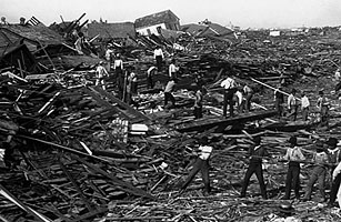
The hurricane that struck Galveston in 1900 completely destroyed the city and covered the area with debris and dead bodies.
This is the aftermath of September 8th hurricane that hit Galveston, Texas in 1900.
This picture shows the survivors picking through the debris and carrying out the deceased after the Galveston Hurricane of 1900.
This picture shows how the dead were carted away after the Galveston Hurricane.
This map shows the Eastern United States and the areas that are highly susceptible to landslides. The coast is especially susceptible because people have been building their houses closer and closer to the coast, removing the natural vegetation. These factors mixed in with earthquakes that are prone to occurring along the west coast and heavy rainfalls can lead to landslides.
This map shows the Eastern United States and areas that are highly susceptible to landslides. Mountain top mining, which is the removal of large areas of the mountains in order to get at precious metals has lead to the removal of natural vegetation and has changed the natural relief of the mountain slopes. These factors along with heavy rainfalls and earthquakes can lead to landslides.